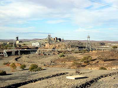
 The following morning we drove out of Broken Hill past more abandoned mines and tailings heaps, heading East for Wilcannia on the 'Barrier Highway' - about 200 km.
A website had mentioned that most tourists drove straight through Wilcannia, seeing only groups of aborigines sitting around drinking, whereas both this historic inland port town and its inhabitants were all very interesting & well worth a stop etc. etc.
So, determined to have no preconceptions, we pulled into Wilcannia with open minds. It was the most profoundly depressing place we had ever seen. With the exception of the Police Station, the Pub and Department of Community Services buildings, every single window in the town was smashed.
 The lovely historic sandstone buildings were burnt and vandalised, floorboards ripped up and doors ripped off to start fires. A graffiti-covered store, corrugated iron nailed over its broken windows, forlornly offered 'Boomerangs for Sale'. It was closed.
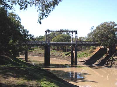
While Joc braved the unspeakable public toilet, I followed a sign saying 'Drinking Area' down to the bottle and can-strewn river bank in order to photograph the historic centre-lift bridge, built to allow the 19th-Century paddlesteamers which brought trade and commerce to the interior to pass beneath.
This muddy trickle is the famous Darling River, which runs '100 miles wide' in flood, and used to carry the paddleboats right up as far as Bourke. We were happy to refuel (112.9c/litre) and leave town.
 Here is where we left the bitumen and turned Northeast for Bourke. We had 270 km of this ahead of us. This was more like the Outback we had expected, and why we had purchased an AWD car.
Fortunately the road had just been re-opened after the rain, and while there were still plenty of soft and boggy places, at least there was no dust and we made good time on the firmer sections.
A similar road also goes up the South side of the Darling, crossing over in two places en route, but otherwise the roads run well away from the river, sometimes visible as a line of large River Red Gums in the distance.
Once again we passed only a couple of cars, heading for Wilcannia.
 About half way up is Tilpa (population 11) which boasts 'The Shortest Heritage Walk in Australia' - through the doorway of the traditional old outback pub, where in exchange for a donation to the Royal Flying Doctor Service, you can write your name on the bar-room wall.
After lunching by the river we pressed on to Bourke. We had been warned that Bourke was a bit of a 'rough' town, an impression reinforced by the steel shutters on all the shop windows.
We ourselves saw no particular evidence of this during our short stay, possibly because the owner of the units we stayed at, insisted that we chain and padlock ourselves in overnight! Nevertheless, we left Bourke without regret early the following morning.
 The countryside beyond Bourke was surprisingly green, although on close examination the vegetation turned out to be mostly the prickly and unpalatable bindi weed.
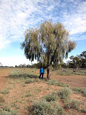
We saw many Coolabah trees, of song and poetic fame, and the most attractive Weeping Myall which is even dense enough to provide some decent shade - quite unusual in an outback tree.
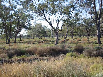
Lower-lying areas had native grasses and denser vegetation - the photo at right should also have contained a large black wild boar which was rooting around next to the road, but it rushed out of frame while the camera was still focusing...
 We found nothing to attract us in Walgett and drove on to Lightning Ridge, where the famous Black Opal is mined. LR is an attractive town of about 6,000 entirely devoted to opal mining, buying and selling. Even the motel rooms have large safes in them!
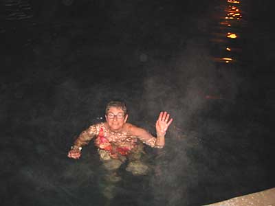
We looked at a few opal galleries but our favourite spot was the hot bore, open for bathing free of charge day and night. The bore is 1025 metres deep into the Great Artesian Basin, and capped to 9 litres per second. Its water is two million years old, and emerges at 41.5 degrees Celsius into a deep public pool.
On these cold Winter nights it was shrouded in steam and we happily luxuriated immersed up to our chins while listening to all the local gossip - mostly about various miners and their rumoured gem finds.
 The following morning we arranged to meet Joc's cousin Toby at the crossroads. Due to me mislaying the camera, the actual moment when these long-lost relatives first clasped each other to their respective bosoms remains sadly unrecorded.
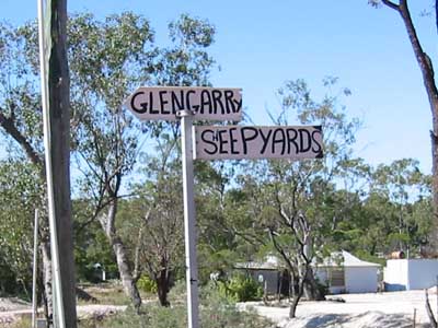
The Grawin, Sheepyards and Glengarry fields are some distance from Lightning Ridge, and their opal is found in thin seams rather than rock nodules. To us the workings looked much the same as those at White Cliffs, but with trees.
There are however no underground dwellings, most miners living in ramshackle, but comfortable, houses called 'camps' on residential (as opposed to working) claims. Power is by generator, and everywhere are old trucks, cars, mining machinery, engines and more engines.
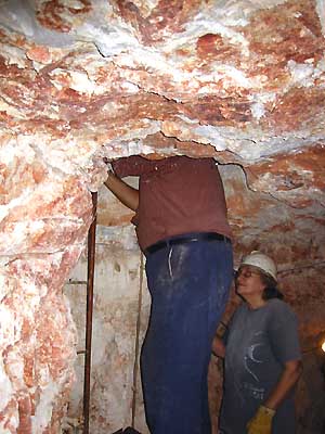
 Here is Joc with Toby and her husband David, an experienced miner both here and in the USA, at their working claim. Behind them is the mineshaft and the tipping hoist, which discharges waste directly into the truck for removal.
Nowadays mineshafts are drilled at '$14 a foot' (compulsory metrication in 1965 not yet a complete success) rather than dug by hand, and initial prospecting on claims is also often done by drilling. Vertical shafts are 30 to 40 feet deep, from which radiate the horizontal 'drives' following, hopefully, seams of opal.
This mine is not very productive however, and Toby buys, sells, cuts and polishes opal in addition to mining. She seems to be quite comfortable with operating mining machinery and working underground - a bit of a change from her previous occupation of psychotherapy.
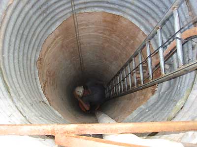 We had come out to the claim to see a working mine. As David removed the cover, Joc took one look down the shaft and immediately announced that she was staying on the surface, thanks very much.
We could not persuade her to climb down the ladders at either shaft, so David started the diesel generator which provided lights, ventilation and power, and he, Toby and I went down into the mine.
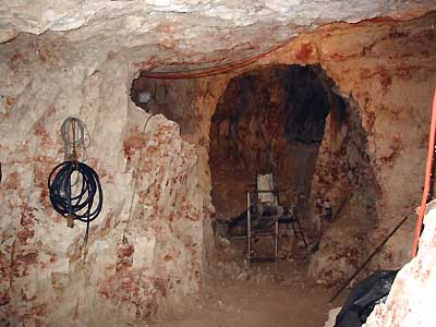
The main shaft is about a metre in diameter and goes down through clay and rock to the working level. The top few feet where the surface soil is looser are lined with corrugated iron. The bucket of the tipping hoist runs up and down the steel ladder, hauled by a greasy wire rope that tends to get in the way a bit when climbing.
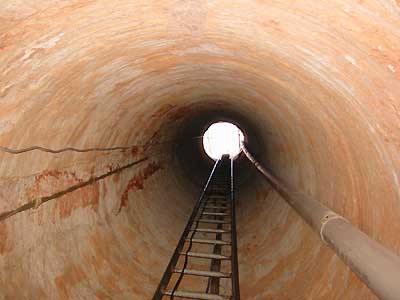 Power cables and ventilator pipes also come down the same shaft, and the characteristic colour of the ground in opal-bearing areas can be seen on the walls.
The air was cool and slightly damp, but due to the ample headroom and the blaze of halogen lighting from the powerful lights everywhere, there was no particular feeling of claustrophobia, unlike the Daydream silver mine.
Most miners nowadays use electric or air-driven jackhammers to remove the tonnes of rock and clay required to find gem-quality opal, which exists in small pockets or seams usually along geological fault-lines in the ground. Many miners struggle for years, even decades, without finding opal. Others become instant millionaires.
 Horizontal passages following the opal-bearing seams ran off in various directions from the bottom of the shaft, but the opal found here so far has been only colourless or 'potch' opal.
After a good look around David offered me a ride up on the tipper bucket. Not trusting my ability to step off in time, and not wishing to be dumped headfirst on the heap I declined, but just managed to catch a picture of David disappearing up the shaft on the bucket. Toby and I climbed out the hard way :)